Question: Is there a tool that offers customizable reports and datasets for crop monitoring, including crop types, field boundaries, and vegetation indices?
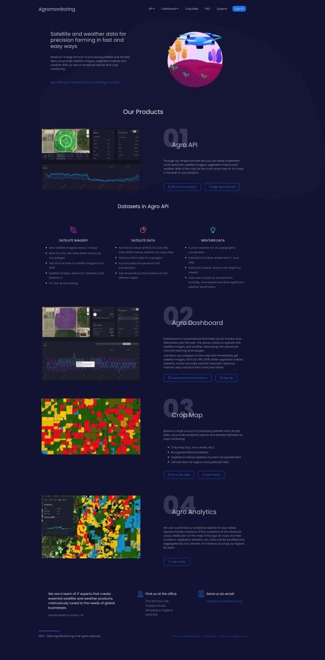
Agromonitoring screenshot thumbnail

Agromonitoring

If you need customizable reports and data sets for crop monitoring, Agromonitoring is a good choice. It offers a range of tools, including Crop Map, which offers analytical reports and data sets for crop monitoring, and Agro Analytics, which offers customizable reports for in-depth crop condition analysis. The service also offers satellite imagery with a 2-4 day refresh rate, historical data archives, a range of vegetation indices and weather data, so it's a good option for farmers and ag developers.

EOSDA screenshot thumbnail

EOSDA

Another good option is EOSDA, a geospatial data analytics service that uses satellite imagery and machine learning algorithms for precision agriculture. It includes tools for crop monitoring, yield forecasting, soil moisture analysis and carbon modeling, among other uses. EOSDA also offers high-resolution satellite imagery and custom pricing deals, so it can be a good option for businesses in the ag industry that want to be more environmentally responsible.

Cropwise screenshot thumbnail

Cropwise

If you want a service that bundles several tools for farm operations, Cropwise is worth a look. It offers a collection of apps for real-time field monitoring, crop health monitoring and personalized seed recommendations. Cropwise can help farmers cut rework, increase crop yields and make data-driven decisions, helping them make proactive and precise decisions.

Esri screenshot thumbnail

Esri

If you want a more general-purpose spatial analytics service, Esri offers GIS mapping software and spatial analytics tools that can be used for crop monitoring and other ag uses. Its tools include 3D visualization, location intelligence and spatial analysis, and can run on cloud computing infrastructure or on-premise, so it's a good option for a variety of use cases in the ag industry.

Additional AI Projects

CARTO screenshot thumbnail

CARTO

Analyze and visualize spatial data at any scale with native cloud integration, intuitive drag-and-drop interface, and built-in GenAI capabilities.

Nearmap screenshot thumbnail

Nearmap

Transforms high-resolution aerial imagery into actionable insights with AI predictions, 3D modeling, and geospatial tools for informed business decisions.

DroneDeploy screenshot thumbnail

DroneDeploy

Combines data from multiple sources, including drones and cameras, into one platform, automating capture and extracting insights with AI for informed decision-making.

ePlant screenshot thumbnail

ePlant

Remotely monitor tree health and environmental conditions with long-range wireless sensors, tracking growth, stress, and weather patterns for data-driven decisions.

Tomorrow.io screenshot thumbnail

Tomorrow.io

Combines global spacecraft data, AI/ML models, and advanced forecasting to provide hyper-accurate weather information for any location, enabling proactive decision-making and resilience.

KNIME screenshot thumbnail

KNIME

Build, deploy, and manage data science solutions with a visual workflow builder, 300+ data connectors, and access to popular machine learning libraries.

GoodData screenshot thumbnail

GoodData

Quickly build custom data products with interactive analytics abilities, leveraging AI-powered features like a no-code interface and chat assistant for effortless insights.

Spotfire screenshot thumbnail

Spotfire

Integrate, prepare, analyze, and act on data from multiple sources with a single platform for real-time data exploration and point-and-click data science.

Canvas screenshot thumbnail

Canvas

Link, query, and visualize data from 150+ SaaS tools without coding, empowering non-technical teams to make data-informed decisions.

Explo screenshot thumbnail

Explo

Embed interactive dashboards and self-serve reporting directly into products, enabling end-users to customize analytics experiences and make better decisions.

Onvo screenshot thumbnail

Onvo

Create interactive charts and insights with simple AI prompts, eliminating the need for complex queries and customizations.

ClientReports screenshot thumbnail

ClientReports

Automatically generate professional client reports with ease, streamlining the process with a 3-shot approach to headers, content, and fine-tuning.

AI Clearing screenshot thumbnail

AI Clearing

Generates 3D site reports with 100% site coverage, providing accurate and efficient progress monitoring, reducing re-work costs and litigation risks.

Tractorscope screenshot thumbnail

Tractorscope

Turn complex data into meaningful insights with customizable dashboards and charts.

Radar screenshot thumbnail

Radar

Radar combines geofencing, geocoding, and mapping for accurate, cost-effective location-based experiences.

Encord screenshot thumbnail

Encord

Streamline computer vision development with automated labeling, data management, and model testing tools to build more accurate models faster.

Spatial.ai screenshot thumbnail

Spatial.ai

Unlock deeper customer insights with behavioral segmentation tools, profiling social, mobile, and web behavior to inform targeted marketing and location strategies.

Meltwater screenshot thumbnail

Meltwater

Unlock powerful data sets and drive strategy with AI-driven insights across media, social, consumer, and sales intelligence, empowering data-informed decisions.

Elastic screenshot thumbnail

Elastic

Combines search and AI to extract meaningful insights from data, accelerating time to insight and enabling tailored experiences.

Datadog screenshot thumbnail

Datadog

Provides real-time visibility into performance, security, and user experience across entire technology stacks, enabling swift troubleshooting and optimization.