Question: Can you suggest a cloud-based platform that integrates with environmental data providers and mapping tools for technical report writing?
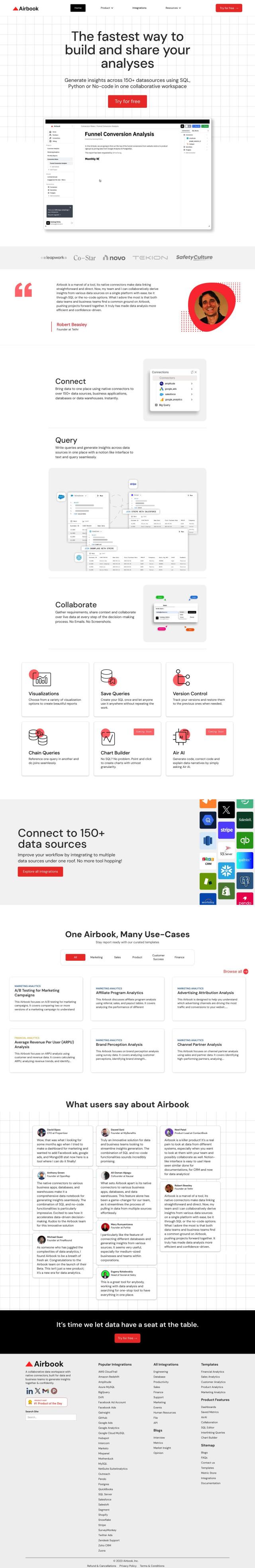
Quire screenshot thumbnail

Quire

For your need for a cloud-based platform that integrates with environmental data providers and mapping tools for technical report writing, Quire is an excellent choice. Quire is a cloud-based technical reporting software designed to enhance productivity and team collaboration. It integrates with third-party services, including environmental data sources and mapping tools, to automate data exchange and streamline workflows. This platform is particularly useful for industries such as architecture, engineering, and construction.

CARTO screenshot thumbnail

CARTO

Another robust option is CARTO, a cloud-native location intelligence platform that excels in analyzing, visualizing, and building applications with spatial data. CARTO offers an intuitive drag-and-drop interface, over 100 pre-built analysis components, and integration with major cloud platforms. It supports scalable app development and includes access to over 12,000 geospatial datasets, making it a powerful tool for organizations looking to leverage spatial analytics and visualization.

Esri screenshot thumbnail

Esri

If you need comprehensive GIS mapping and spatial analytics, Esri is a leading platform. It offers a wide range of features including 3D visualization, location intelligence, and spatial analysis. Esri is suitable for various industries and use cases, from retail site selection to infrastructure planning and climate action, and can be deployed on cloud infrastructure or on-premise.

Nearmap screenshot thumbnail

Nearmap

For those looking for high-resolution imagery and 3D modeling, Nearmap is a compelling choice. It provides current aerial imagery, AI-generated datasets, and geospatial tools designed to help businesses and governments make better decisions. Nearmap's platform can be particularly useful for urban planning, environmental impact assessments, and disaster response.

Additional AI Projects

Mapbox screenshot thumbnail

Mapbox

Create customizable, interactive maps with live-updating data and advanced navigation features for web, mobile, automotive, and AR applications.

EOSDA screenshot thumbnail

EOSDA

Utilizes satellite data and machine learning to provide actionable insights for sustainable agriculture and forestry, enabling data-driven decision making and reduced waste.

Cloudera screenshot thumbnail

Cloudera

Unifies and processes massive amounts of data from multiple sources, providing trusted insights and fueling AI model development across cloud and on-premises environments.

Hexagon screenshot thumbnail

Hexagon

Combines sensor, software, and autonomous technologies to increase efficiency, reduce waste, and improve sustainability across industries through data-driven digital reality solutions.

LSEG Data & Analytics screenshot thumbnail

LSEG Data & Analytics

Empowers financial decision-making with global market data, AI-powered analytics, and collaborative workflow solutions, providing comprehensive insights and interoperability.

Altova screenshot thumbnail

Altova

Graphical data mapping and conversion between formats, advanced XML and JSON editing, and customizable reporting and contract management solutions.

CarbonReach screenshot thumbnail

CarbonReach

Combines device, location, network, and behavior data to predict future risks, providing a comprehensive view of network activity for targeted security action.

Electricity Maps screenshot thumbnail

Electricity Maps

Access real-time, historical, and forecasted carbon intensity data for 230+ regions to inform energy decisions and reduce carbon footprint.

Hex screenshot thumbnail

Hex

Unify data teams with AI-assisted exploration, collaboration, and interactive reporting, accelerating data work and improving accuracy in a single, modular workspace.

Narrative screenshot thumbnail

Narrative

Automates data operations with AI-infused tools, enabling teams to focus on higher-level work while ensuring data standardization, collaboration, and security.

Silatus screenshot thumbnail

Silatus

Generates detailed, fact-based reports on any topic, drawing from over 100,000 sources, with customizable templates and secure file uploads.

GoodData screenshot thumbnail

GoodData

Quickly build custom data products with interactive analytics abilities, leveraging AI-powered features like a no-code interface and chat assistant for effortless insights.

AI Clearing screenshot thumbnail

AI Clearing

Generates 3D site reports with 100% site coverage, providing accurate and efficient progress monitoring, reducing re-work costs and litigation risks.

Airbook screenshot thumbnail

Airbook

Accelerate data analysis and insights generation across teams with native connectors to 150+ data sources, collaborative querying, and visualization tools.

Estuary screenshot thumbnail

Estuary

Build and automate fast, reliable, and low-latency data pipelines with 100+ no-code connectors for real-time CDC, ETL, and streaming data integration.

ePlant screenshot thumbnail

ePlant

Remotely monitor tree health and environmental conditions with long-range wireless sensors, tracking growth, stress, and weather patterns for data-driven decisions.

Lume screenshot thumbnail

Lume

Automates data mapping with AI, generating mapping logic in seconds, and updating it when schema changes, to ensure data consistency and accuracy.

Elastic screenshot thumbnail

Elastic

Combines search and AI to extract meaningful insights from data, accelerating time to insight and enabling tailored experiences.

ThoughtSpot screenshot thumbnail

ThoughtSpot

Ask complex data questions in natural language and get instant AI-powered insights, empowering informed business decisions without requiring SQL or data expertise.

Mode screenshot thumbnail

Mode

Unify data analysis and visualization with SQL, R, Python, and interactive dashboards to accelerate insights and collaboration across teams.