Google Maps Platform Alternatives

Unlock location-based insights and enhance user experiences with customizable, real-time maps, routes, and geospatial data for informed decision-making.
Mapbox screenshot thumbnail

Mapbox

If you're looking for a replacement for Google Maps Platform, Mapbox is a top contender. It offers customizable maps, sophisticated navigation and rich geospatial data. With tools like interactive maps, routing engines and location search, Mapbox offers a powerful foundation for developers building location-based apps. It's used by more than a half billion people monthly, and you can use it for free with volume discounts and annual payments to cut costs as usage increases.

MapmyIndia screenshot thumbnail

MapmyIndia

Another good option is MapmyIndia, particularly if you're interested in detailed maps and navigation for the Indian market. It offers a range of APIs and SDKs for navigation, traffic, search and other tasks. Among its services are HD Maps, RealView 360° and AI-powered geospatial analytics, and it's geared for customers like automotive and government. The idea is to help customers improve their customer experience and governance and infrastructure.

Nearmap screenshot thumbnail

Nearmap

If you're interested in location intelligence and high-resolution imagery, Nearmap brings a different set of tools to the table. It offers up-to-date aerial imagery, 3D modeling and AI-generated data sets for property attributes. That can be useful for urban planning, emergency response and real estate. Nearmap is geared toward providing high-quality imagery that's up to date, so if you need location data that's detailed and current, it's a good option.
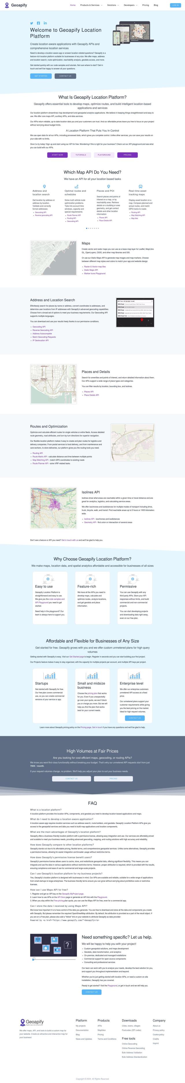
Geoapify screenshot thumbnail

Geoapify

Last, Geoapify is a good option for developers who want to build location-based apps. It offers a range of tools for mapping, geocoding, route optimization and spatial analysis. With customizable maps, address and location search and route optimization, Geoapify offers a solid foundation for building interactive and dynamic maps. It offers a free plan with 3,000 credits per day and tiered pricing plans for different usage levels.

More Alternatives to Google Maps Platform

Spatial.ai screenshot thumbnail

Spatial.ai

Unlock deeper customer insights with behavioral segmentation tools, profiling social, mobile, and web behavior to inform targeted marketing and location strategies.

Bluedot screenshot thumbnail

Bluedot

Empowers apps to send targeted messages and automate tasks with 20x accurate location detection, down to five meters, for seamless customer experiences.

MOCA screenshot thumbnail

MOCA

Creates dynamic audience segments and delivers personalized experiences using AI-powered marketing solutions and location intelligence.

Placer.ai screenshot thumbnail

Placer.ai

Gain unprecedented visibility into consumer behavior, track migration patterns, and uncover market trends with actionable data-driven insights for informed business decisions.

Placekey screenshot thumbnail

Placekey

Assigns a unique identifier to any physical location, standardizing address information for easy data sharing and integration across organizations.

Unearth Insights screenshot thumbnail

Unearth Insights

Access a unified suite of location data and analytics tools, powered by an AI co-pilot, to uncover insights and drive business decisions faster.

DispatchTrack screenshot thumbnail

DispatchTrack

AI-optimized routes and real-time order tracking improve last-mile delivery customer satisfaction, promising speed, precision, and personalized experiences.

Flybuy screenshot thumbnail

Flybuy

Provides accurate location intelligence, going beyond traditional geofence technology, to improve guest experience and streamline operations for various industries.

Blue Yonder screenshot thumbnail

Blue Yonder

Unifies supply chain planning with predictive analytics, end-to-end visibility, and autonomous operations to simplify complex networks and unlock future opportunities.

Movement screenshot thumbnail

Movement

Revolutionize logistics operations with real-time visibility, automation, and advanced analytics, optimizing routes, inventory, and freight costs across multiple carriers and industries.

Loqate screenshot thumbnail

Loqate

Enhance address data quality and user experience with fast and accurate capture, verification, and geocoding technology for 249 countries and territories.

Kinaxis screenshot thumbnail

Kinaxis

Empowers companies to respond to disruptions and uncertainty with agility and confidence through AI-driven transparency and collaborative decision-making.

CARTO screenshot thumbnail

CARTO

Analyze and visualize spatial data at any scale with native cloud integration, intuitive drag-and-drop interface, and built-in GenAI capabilities.

Esri screenshot thumbnail

Esri

Uncover hidden patterns and drive predictive modeling with spatial analytics and machine learning, combining location-based data for innovative insights.

Radar screenshot thumbnail

Radar

Radar combines geofencing, geocoding, and mapping for accurate, cost-effective location-based experiences.

Shipsy screenshot thumbnail

Shipsy

Optimizes end-to-end logistics and supply chain operations with automated route planning, freight procurement, and shipment tracking for improved efficiency and cost reduction.

Omnitracs screenshot thumbnail

Omnitracs

Combines fleet management expertise with AI and machine learning to provide actionable insights, optimize business performance, and improve driver satisfaction and safety.

Uber Freight screenshot thumbnail

Uber Freight

Provides real-time visibility and AI-optimized decision-making to modernize supply chains, enabling data-driven operations and optimized logistics solutions.

BigDataCloud screenshot thumbnail

BigDataCloud

Unlock accurate location data and automate business processes with BigDataCloud's APIs.

INRIX screenshot thumbnail

INRIX

Harnesses 50 petabytes of transportation data to provide real-time traffic insights, crash alerts, and parking analytics, optimizing urban mobility and road safety.