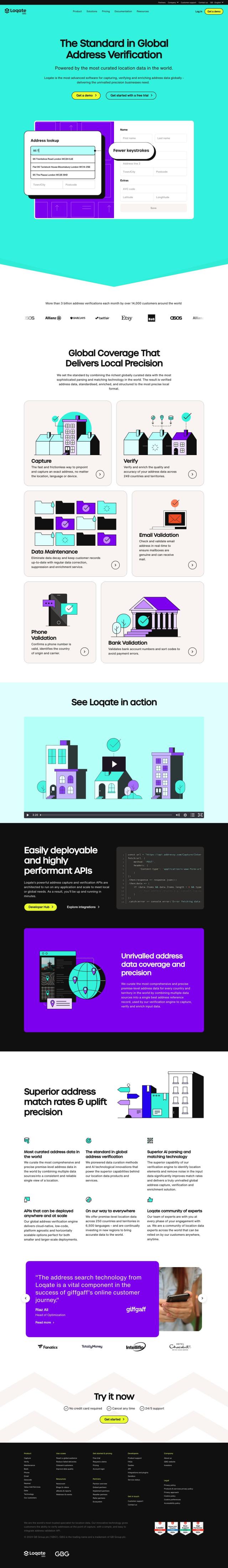
Question: Can you recommend a mapping solution that includes geocoding APIs and routing APIs for distance optimization?

Radar screenshot thumbnail

Radar

If you need a full-featured mapping product with geocoding and routing APIs, Radar is a great option. Radar has high-accuracy geofencing, powerful mapping features and a big priority on privacy and developer experience. It includes geocoding APIs, search APIs and routing APIs, along with a tiered pricing system and integration with popular tools like Segment and Braze. Radar also offers enterprise-grade privacy and security with SOC 2 type II certification and GDPR compliance.

Mapbox screenshot thumbnail

Mapbox

Another top contender is Mapbox, which offers customizable maps, sophisticated navigation and detailed geospatial data. Mapbox offers interactive maps with live-updating data, advanced routing engines and precise location search. It supports developers with a wealth of documentation and makes it easy to incorporate custom data, making it a good choice for connected navigation and data analysis. Mapbox charges by usage, with a free tier and discounts for large volumes of usage.

MapmyIndia screenshot thumbnail

MapmyIndia

If you're looking for something more location-focused, MapmyIndia has a range of location-based products and services built on India's most accurate maps. It includes APIs and SDKs for maps, traffic, search, geocoding, routes, navigation, mobility and tracking. MapmyIndia also offers AI-powered geospatial analytics and IoT solutions for customers in automotive and government. It's a good choice for developers who want to build customized experiences on top of a solid mapping foundation.

Additional AI Projects

Esri screenshot thumbnail

Esri

Uncover hidden patterns and drive predictive modeling with spatial analytics and machine learning, combining location-based data for innovative insights.

CARTO screenshot thumbnail

CARTO

Analyze and visualize spatial data at any scale with native cloud integration, intuitive drag-and-drop interface, and built-in GenAI capabilities.

Routora screenshot thumbnail

Routora

Reorders stops for the most efficient route, minimizing backtracking and saving time and fuel, with easy upload and download of optimized routes.

DispatchTrack screenshot thumbnail

DispatchTrack

AI-optimized routes and real-time order tracking improve last-mile delivery customer satisfaction, promising speed, precision, and personalized experiences.

INRIX screenshot thumbnail

INRIX

Harnesses 50 petabytes of transportation data to provide real-time traffic insights, crash alerts, and parking analytics, optimizing urban mobility and road safety.

Omnitracs screenshot thumbnail

Omnitracs

Combines fleet management expertise with AI and machine learning to provide actionable insights, optimize business performance, and improve driver satisfaction and safety.

PlaceKit screenshot thumbnail

PlaceKit

Fast, accurate, and global address search with autocomplete, geocoding, and store locator features for seamless user experiences and efficient address management.

Placekey screenshot thumbnail

Placekey

Assigns a unique identifier to any physical location, standardizing address information for easy data sharing and integration across organizations.

Urbantz screenshot thumbnail

Urbantz

Optimizes last mile logistics with AI-driven route planning, real-time delivery slots, and multi-carrier management to increase successful deliveries and customer satisfaction.

Geotab screenshot thumbnail

Geotab

Leverage AI-driven insights and recommendations to optimize fleet operations, improve safety, and reduce emissions, while automating compliance and increasing productivity.

Loqate screenshot thumbnail

Loqate

Enhance address data quality and user experience with fast and accurate capture, verification, and geocoding technology for 249 countries and territories.

Nearmap screenshot thumbnail

Nearmap

Transforms high-resolution aerial imagery into actionable insights with AI predictions, 3D modeling, and geospatial tools for informed business decisions.

Unearth Insights screenshot thumbnail

Unearth Insights

Access a unified suite of location data and analytics tools, powered by an AI co-pilot, to uncover insights and drive business decisions faster.

Samsara screenshot thumbnail

Samsara

Samsara's fleet operations platform connects cameras, sensors, and workflows for faster, more confident decisions.

Flybuy screenshot thumbnail

Flybuy

Provides accurate location intelligence, going beyond traditional geofence technology, to improve guest experience and streamline operations for various industries.

Arity screenshot thumbnail

Arity

Analyzes trillions of miles of driving data to provide actionable insights for insurers, marketers, and communities, enabling personalized services and targeted solutions.

Spatial.ai screenshot thumbnail

Spatial.ai

Unlock deeper customer insights with behavioral segmentation tools, profiling social, mobile, and web behavior to inform targeted marketing and location strategies.

Bluedot screenshot thumbnail

Bluedot

Empowers apps to send targeted messages and automate tasks with 20x accurate location detection, down to five meters, for seamless customer experiences.

Rapid Editor screenshot thumbnail

Rapid Editor

Automates map creation and updates using machine learning and satellite imagery, reducing manual effort and increasing accuracy.

Textomap screenshot thumbnail

Textomap

Automatically extracts locations from text-based content to create interactive maps in seconds, saving time and effort.

RoutePerfect screenshot thumbnail

RoutePerfect

Creates personalized travel itineraries based on preferences, budget, and style, combining AI technology with crowdsourced data from thousands of tested trips.