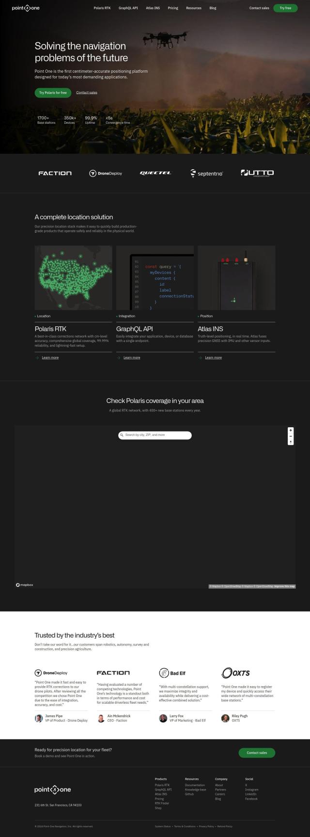
Point One Alternatives

Achieve centimeter-accurate globally-referenced position data in challenging environments with a complete location solution, featuring RTK corrections and real-time truth-level positioning.
Mapbox screenshot thumbnail

Mapbox

If you're looking for a Point One replacement, Mapbox is a good choice. It offers APIs and SDKs for building custom maps, sophisticated navigation and location search. The service offers interactive maps that can be updated in real time and access to a wealth of global data. It's used for connected navigation, weather forecasting, data analysis and smart location features, so it's adaptable for a variety of uses.

FlyPix screenshot thumbnail

FlyPix

Another good Point One alternative is FlyPix, an AI-powered geospatial solutions platform. It transforms complex imagery into actionable, geo-referenced insights, including object detection, localization, tracking and monitoring. It's geared for industries like government, construction, renewable energy and agriculture, with features like heat map generation and API access.

Radar screenshot thumbnail

Radar

If you're concerned with location accuracy and privacy, Radar is an all-in-one location platform. It offers hyper-accurate geofencing, geocoding and mapping. Radar is focused on accuracy, privacy and developer experience, with unlimited geofences and SOC 2 type II certification for enterprise security compliance.
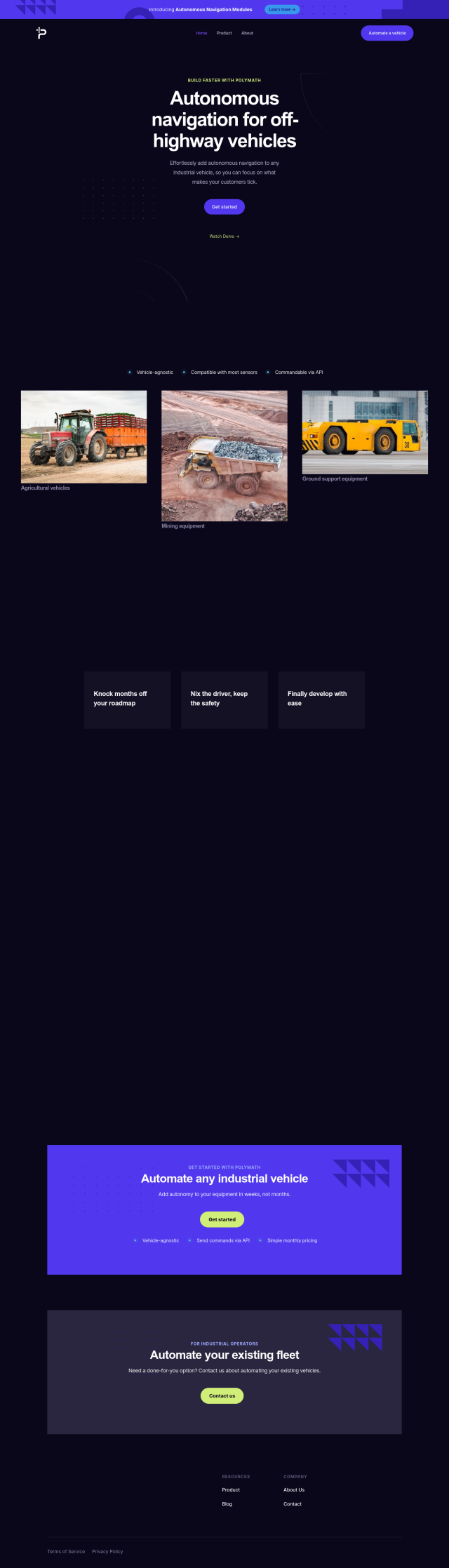
Polymath Robotics screenshot thumbnail

Polymath Robotics

Last, Polymath Robotics has an autonomous navigation service for industrial off-highway vehicles, letting you automate fleets quickly. The service is vehicle-agnostic and can be integrated with a variety of sensors and other software with an API. It offers features like waypoint navigation, obstacle detection and performance monitoring, so it's a good option for automating industrial fleets.

More Alternatives to Point One

Skydio screenshot thumbnail

Skydio

Capture detailed data in challenging environments with AI-powered autonomous drones, featuring ultra-high resolution cameras and obstacle avoidance.

Nearmap screenshot thumbnail

Nearmap

Transforms high-resolution aerial imagery into actionable insights with AI predictions, 3D modeling, and geospatial tools for informed business decisions.

MapmyIndia screenshot thumbnail

MapmyIndia

Seamlessly navigate and optimize last-mile operations with integrated navigation, route planning, and location intelligence solutions powered by India's best maps.

Hexagon screenshot thumbnail

Hexagon

Combines sensor, software, and autonomous technologies to increase efficiency, reduce waste, and improve sustainability across industries through data-driven digital reality solutions.

Trackunit screenshot thumbnail

Trackunit

Connects people, machines, and processes to minimize downtime, optimize operations, and increase productivity in the construction industry.

PIX4D screenshot thumbnail

PIX4D

Converts images into accurate maps and 3D models for analysis, inspections, and measurements, with survey-grade accuracy and georeferencing.

Esri screenshot thumbnail

Esri

Uncover hidden patterns and drive predictive modeling with spatial analytics and machine learning, combining location-based data for innovative insights.

Wemap screenshot thumbnail

Wemap

Build interactive maps with augmented reality, indoor and outdoor navigation, and search capabilities for web and mobile applications.

CupixWorks screenshot thumbnail

CupixWorks

Automatically transforms 360-degree capture videos into as-built 3D spatial context for construction projects and facility management, improving project efficiency and accuracy.

EasyAR screenshot thumbnail

EasyAR

Enables developers to build augmented reality experiences with features like spatial mapping, motion tracking, and image recognition, with flexible toolchains for rapid development.

Geotab screenshot thumbnail

Geotab

Leverage AI-driven insights and recommendations to optimize fleet operations, improve safety, and reduce emissions, while automating compliance and increasing productivity.

Mappedin screenshot thumbnail

Mappedin

Create interactive 3D indoor maps with AI-assisted tools, automated navigation, and content enrichment, and share them across various devices and formats.

Teletrac Navman screenshot thumbnail

Teletrac Navman

Unify fleet operations with a single platform, tracking and optimizing vehicles, equipment, and drivers in real-time, improving safety, efficiency, and performance.

Meteomatics screenshot thumbnail

Meteomatics

Access global high-resolution weather, ocean, environment, and climate data through a comprehensive API, including historical, real-time, and forecast data up to 2100.

AI Clearing screenshot thumbnail

AI Clearing

Generates 3D site reports with 100% site coverage, providing accurate and efficient progress monitoring, reducing re-work costs and litigation risks.

Agromonitoring screenshot thumbnail

Agromonitoring

Provides precision farming insights through satellite imagery, vegetation indices, and weather data, empowering data-driven crop management and decision-making.

LocoNav screenshot thumbnail

LocoNav

AI-powered video technology analyzes traffic, identifies safety risks, and provides real-time alerts to mitigate risks and ensure a safer, more efficient fleet.

Placekey screenshot thumbnail

Placekey

Assigns a unique identifier to any physical location, standardizing address information for easy data sharing and integration across organizations.

Foxglove screenshot thumbnail

Foxglove

Visualize and inspect multimodal data, including 3D scenes, images, and diagnostics, to accelerate robotics development and streamline data analysis.

Geoapify screenshot thumbnail

Geoapify

Build location-based apps with ease using a suite of APIs for mapping, geocoding, route optimization, and spatial analytics, with flexible pricing and no data restrictions.