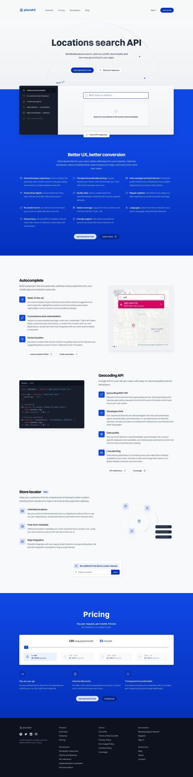
Mapbox Alternatives

Create customizable, interactive maps with live-updating data and advanced navigation features for web, mobile, automotive, and AR applications.

If you're looking for alternatives to Mapbox, there are several compelling options that offer a range of features for location intelligence and geospatial data.

Esri screenshot thumbnail

Esri

Esri is a robust option that combines GIS mapping with spatial analytics and machine learning. It provides comprehensive tools for location intelligence, 3D visualization, and real-time decision-making. Esri is suitable for a variety of industries, including retail, asset management, and infrastructure planning, and offers a 21-day free trial with extensive developer resources.

MapmyIndia screenshot thumbnail

MapmyIndia

Another strong contender is MapmyIndia, which focuses on providing accurate maps and location-based solutions for India. It offers APIs and SDKs for navigation, traffic, search, and geocoding, along with advanced geospatial analytics. MapmyIndia is particularly useful for enterprise, automotive and government sectors, and provides a range of consumer products for accurate navigation.

Radar screenshot thumbnail

Radar

For those emphasizing accuracy and privacy, Radar is an excellent choice. Radar provides hyper-accurate geofencing and robust mapping capabilities, including geocoding, search and routing APIs. The platform is designed for ease of integration with popular tools and offers strong privacy and security features, making it a reliable alternative to Mapbox.

More Alternatives to Mapbox

CARTO screenshot thumbnail

CARTO

Analyze and visualize spatial data at any scale with native cloud integration, intuitive drag-and-drop interface, and built-in GenAI capabilities.

PlaceKit screenshot thumbnail

PlaceKit

Fast, accurate, and global address search with autocomplete, geocoding, and store locator features for seamless user experiences and efficient address management.

Unearth Insights screenshot thumbnail

Unearth Insights

Access a unified suite of location data and analytics tools, powered by an AI co-pilot, to uncover insights and drive business decisions faster.

Placekey screenshot thumbnail

Placekey

Assigns a unique identifier to any physical location, standardizing address information for easy data sharing and integration across organizations.

Geotab screenshot thumbnail

Geotab

Leverage AI-driven insights and recommendations to optimize fleet operations, improve safety, and reduce emissions, while automating compliance and increasing productivity.

INRIX screenshot thumbnail

INRIX

Harnesses 50 petabytes of transportation data to provide real-time traffic insights, crash alerts, and parking analytics, optimizing urban mobility and road safety.

Spatial.ai screenshot thumbnail

Spatial.ai

Unlock deeper customer insights with behavioral segmentation tools, profiling social, mobile, and web behavior to inform targeted marketing and location strategies.

Textomap screenshot thumbnail

Textomap

Automatically extracts locations from text-based content to create interactive maps in seconds, saving time and effort.

Flybuy screenshot thumbnail

Flybuy

Provides accurate location intelligence, going beyond traditional geofence technology, to improve guest experience and streamline operations for various industries.

Bluedot screenshot thumbnail

Bluedot

Empowers apps to send targeted messages and automate tasks with 20x accurate location detection, down to five meters, for seamless customer experiences.

Omnitracs screenshot thumbnail

Omnitracs

Combines fleet management expertise with AI and machine learning to provide actionable insights, optimize business performance, and improve driver satisfaction and safety.

Uber Freight screenshot thumbnail

Uber Freight

Provides real-time visibility and AI-optimized decision-making to modernize supply chains, enabling data-driven operations and optimized logistics solutions.

Urbantz screenshot thumbnail

Urbantz

Optimizes last mile logistics with AI-driven route planning, real-time delivery slots, and multi-carrier management to increase successful deliveries and customer satisfaction.

Ably screenshot thumbnail

Ably

Build real-time digital experiences with APIs for live chat, data broadcast, synchronization, and notifications, ensuring reliable delivery at global scale.

MapsGPT screenshot thumbnail

MapsGPT

Instantly generate custom maps with pins for specific activities, trips, or atmospheres, and discover unique locations with a range of search options.

Elastic screenshot thumbnail

Elastic

Combines search and AI to extract meaningful insights from data, accelerating time to insight and enabling tailored experiences.

Shipsy screenshot thumbnail

Shipsy

Optimizes end-to-end logistics and supply chain operations with automated route planning, freight procurement, and shipment tracking for improved efficiency and cost reduction.

DispatchTrack screenshot thumbnail

DispatchTrack

AI-optimized routes and real-time order tracking improve last-mile delivery customer satisfaction, promising speed, precision, and personalized experiences.

Arity screenshot thumbnail

Arity

Analyzes trillions of miles of driving data to provide actionable insights for insurers, marketers, and communities, enabling personalized services and targeted solutions.

Reform screenshot thumbnail

Reform

Automates logistics operations by extracting data from documents using multimodal AI models, streamlining workflows and recovering thousands of hours per month.

Routora screenshot thumbnail

Routora

Reorders stops for the most efficient route, minimizing backtracking and saving time and fuel, with easy upload and download of optimized routes.