Question: I need a system that can analyze and visualize location-based data to improve transportation infrastructure planning.

CARTO screenshot thumbnail

CARTO

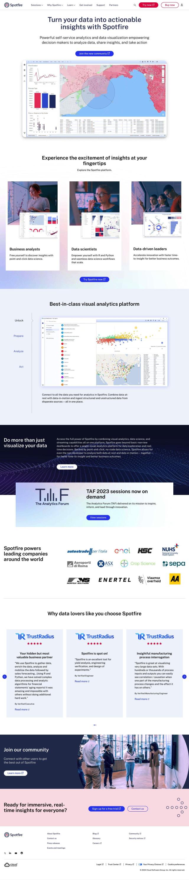
If you're looking for a system to process and visualize location-based data for transportation infrastructure planning, CARTO is a good option. It's a cloud-native location intelligence platform for processing and visualizing spatial data at large scale. With a drag-and-drop interface, more than 100 pre-built analysis components and built-in GenAI abilities, CARTO has powerful spatial analytics and rich data visualization abilities. It also supports scalable app development and comes with access to more than 12,000 geospatial datasets, making it a good option for organizations looking to generate business insights and make decisions.

INRIX screenshot thumbnail

INRIX

Another option is INRIX, which aggregates 50 petabytes of rich transportation data to help customers improve urban mobility. INRIX offers real-time traffic data, crash data, safety alerts and location intelligence, among other options. Its generative AI technology, Compass, can help customers understand traffic patterns and mobility trends to make better decisions and improve safety. The platform is geared for cities, carmakers, transportation agencies and businesses looking to improve their urban mobility systems.

Esri screenshot thumbnail

Esri

If you're looking for a full-featured GIS mapping software, Esri has a powerful platform that marries location analytics with machine learning. Esri's tools include 3D visualization, GIS mapping, spatial analysis and real-time decision-making. It's good for a variety of industries, including infrastructure planning, and offers 21-day free trials and lots of training resources.

Mapbox screenshot thumbnail

Mapbox

Mapbox is another good option for location intelligence, with customizable maps, advanced navigation and geospatial data. With APIs and SDKs for interactive maps and traffic-aware travel times, Mapbox lets you integrate your own data and offers a lot of documentation for developers. It's commonly used for things like navigation and data analysis, and offers a free tier with volume discounts for heavy usage.

Additional AI Projects

Nearmap screenshot thumbnail

Nearmap

Transforms high-resolution aerial imagery into actionable insights with AI predictions, 3D modeling, and geospatial tools for informed business decisions.

MapmyIndia screenshot thumbnail

MapmyIndia

Seamlessly navigate and optimize last-mile operations with integrated navigation, route planning, and location intelligence solutions powered by India's best maps.

Arity screenshot thumbnail

Arity

Analyzes trillions of miles of driving data to provide actionable insights for insurers, marketers, and communities, enabling personalized services and targeted solutions.

Placekey screenshot thumbnail

Placekey

Assigns a unique identifier to any physical location, standardizing address information for easy data sharing and integration across organizations.

Sentiance screenshot thumbnail

Sentiance

Provides real-time driving insights, crash detection, and mobility analysis to improve road safety, reduce risks, and promote sustainable transportation.

Unearth Insights screenshot thumbnail

Unearth Insights

Access a unified suite of location data and analytics tools, powered by an AI co-pilot, to uncover insights and drive business decisions faster.

Hexagon screenshot thumbnail

Hexagon

Combines sensor, software, and autonomous technologies to increase efficiency, reduce waste, and improve sustainability across industries through data-driven digital reality solutions.

Spatial.ai screenshot thumbnail

Spatial.ai

Unlock deeper customer insights with behavioral segmentation tools, profiling social, mobile, and web behavior to inform targeted marketing and location strategies.

Omnitracs screenshot thumbnail

Omnitracs

Combines fleet management expertise with AI and machine learning to provide actionable insights, optimize business performance, and improve driver satisfaction and safety.

Samsara screenshot thumbnail

Samsara

Samsara's fleet operations platform connects cameras, sensors, and workflows for faster, more confident decisions.

CarbonReach screenshot thumbnail

CarbonReach

Combines device, location, network, and behavior data to predict future risks, providing a comprehensive view of network activity for targeted security action.

Tableau screenshot thumbnail

Tableau

Connect to any data source, create visualizations, and share insights with an intuitive, AI-infused analytics platform that drives better decision-making.

Intrado screenshot thumbnail

Intrado

Enhance emergency response with AI-powered PSAP solutions, improving team performance and decision-making for faster, more accurate connections between callers and responders.

Neo4j screenshot thumbnail

Neo4j

Analyze complex data with a graph database model, leveraging vector search and analytics for improved AI and ML model performance at scale.

Urbantz screenshot thumbnail

Urbantz

Optimizes last mile logistics with AI-driven route planning, real-time delivery slots, and multi-carrier management to increase successful deliveries and customer satisfaction.

Spotfire screenshot thumbnail

Spotfire

Integrate, prepare, analyze, and act on data from multiple sources with a single platform for real-time data exploration and point-and-click data science.

Qlik screenshot thumbnail

Qlik

Unifies data from hundreds of sources into a single fabric, enabling customers to integrate, transform, analyze, and take action on their data for better decisions.

ThoughtSpot screenshot thumbnail

ThoughtSpot

Ask complex data questions in natural language and get instant AI-powered insights, empowering informed business decisions without requiring SQL or data expertise.

Rasgo screenshot thumbnail

Rasgo

Ask plain language questions and get instant, automated insights with 24/7 intelligent analysis, secured and customized with business context and visualizations.

Onvo screenshot thumbnail

Onvo

Create interactive charts and insights with simple AI prompts, eliminating the need for complex queries and customizations.