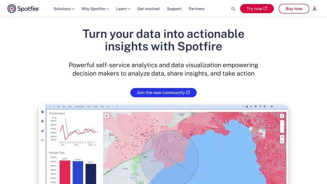
Question: Do you know of a geospatial platform that can integrate with various image types and provide advanced analytics and visualization tools?

FlyPix screenshot thumbnail

FlyPix

If you're looking for a geospatial platform that can handle a variety of image formats and that offers more advanced analytics and visualization tools, FlyPix is a good option. FlyPix uses AI to detect, locate, track and monitor objects, and it offers a range of tools for analyzing and visualizing geospatial data, including heat maps and API integration.

Esri screenshot thumbnail

Esri

Another powerful option is Esri, which offers a broad range of GIS mapping software and spatial analytics tools. It marries location analytics with machine learning to provide 3D visualization, GIS mapping, spatial analysis and real-time decision-making. It's good for retail site selection, infrastructure planning and asset management, and can run in the cloud or on-premises.

CARTO screenshot thumbnail

CARTO

CARTO is a cloud-based location intelligence platform that lets you analyze and visualize spatial data at large scale. It integrates with other cloud-based data sources like BigQuery, Snowflake and Azure, and offers strong security and authentication. CARTO's drag-and-drop interface and suite of analysis tools make it a good option for companies that want to use spatial analysis to drive business insights.

Nearmap screenshot thumbnail

Nearmap

Last, Nearmap offers high-resolution imagery, 3D modeling and AI predictions to help businesses and governments make better decisions. With tools for property attribute analysis, environmental monitoring and disaster response, Nearmap is good for real estate, insurance and emergency services. Its aerial imagery is new and innovative, and its 3D visualization is very detailed, so it's a good option for a wide range of uses.

Additional AI Projects

PIX4D screenshot thumbnail

PIX4D

Converts images into accurate maps and 3D models for analysis, inspections, and measurements, with survey-grade accuracy and georeferencing.

Mapbox screenshot thumbnail

Mapbox

Create customizable, interactive maps with live-updating data and advanced navigation features for web, mobile, automotive, and AR applications.

Hexagon screenshot thumbnail

Hexagon

Combines sensor, software, and autonomous technologies to increase efficiency, reduce waste, and improve sustainability across industries through data-driven digital reality solutions.

MapmyIndia screenshot thumbnail

MapmyIndia

Seamlessly navigate and optimize last-mile operations with integrated navigation, route planning, and location intelligence solutions powered by India's best maps.

OpenSearch screenshot thumbnail

OpenSearch

Build scalable, high-performance search solutions with out-of-the-box performance, machine learning integrations, and powerful analytics capabilities.

Google Maps Platform screenshot thumbnail

Google Maps Platform

Unlock location-based insights and enhance user experiences with customizable, real-time maps, routes, and geospatial data for informed decision-making.

HEAVY.AI screenshot thumbnail

HEAVY.AI

Unlocks high-value opportunities and risks in location and time data through interactive, timely, and hardware-accelerated analytics.

Unearth Insights screenshot thumbnail

Unearth Insights

Access a unified suite of location data and analytics tools, powered by an AI co-pilot, to uncover insights and drive business decisions faster.

Mappedin screenshot thumbnail

Mappedin

Create interactive 3D indoor maps with AI-assisted tools, automated navigation, and content enrichment, and share them across various devices and formats.

LightBox screenshot thumbnail

LightBox

Unifies comprehensive property data, including building footprints, tax parcels, and environmental data, to inform confident commercial real estate decisions.

Spatial.ai screenshot thumbnail

Spatial.ai

Unlock deeper customer insights with behavioral segmentation tools, profiling social, mobile, and web behavior to inform targeted marketing and location strategies.

Imagga screenshot thumbnail

Imagga

Automatically tag, categorize, and search images with customizable machine learning technology for smart applications.

LandingLens screenshot thumbnail

LandingLens

Unlock insights from unlabeled images, achieve accurate results, and deploy computer vision models flexibly and scalably across industries.

Qlik screenshot thumbnail

Qlik

Unifies data from hundreds of sources into a single fabric, enabling customers to integrate, transform, analyze, and take action on their data for better decisions.

Dataloop screenshot thumbnail

Dataloop

Unify data, models, and workflows in one environment, automating pipelines and incorporating human feedback to accelerate AI application development and improve quality.

Wikitude Augmented Reality screenshot thumbnail

Wikitude Augmented Reality

Build immersive AR experiences with image and object tracking, instant tracking, and geo AR, enabling interactive digital content in real-world environments.

Spotfire screenshot thumbnail

Spotfire

Integrate, prepare, analyze, and act on data from multiple sources with a single platform for real-time data exploration and point-and-click data science.

ezML screenshot thumbnail

ezML

Add custom computer vision abilities to apps with a simple API, leveraging prebuilt models for image classification, object detection, and facial analysis.

V7 screenshot thumbnail

V7

Automates machine learning development tasks, including image and video labeling, to accelerate product delivery and reduce labeling costs by up to 80%.

Ontotext screenshot thumbnail

Ontotext

Connects disparate data sources with a large-scale knowledge graph, combining AI-infused tools for enterprise knowledge graphs, metadata management, and content analysis.