Question: I'm looking for a tool that provides high-resolution panoramic imagery for measuring dimensions and analyzing areas.

Nearmap screenshot thumbnail

Nearmap

If you need high-resolution panoramic imagery for measuring dimensions and calculating area, Nearmap is a good option. The service offers high-resolution aerial imagery, 3D modeling, AI predictions and geospatial analysis. Its panoramic and oblique imagery lets you see 360 degrees around a site for urban planning, environmental assessments, construction projects and other uses.
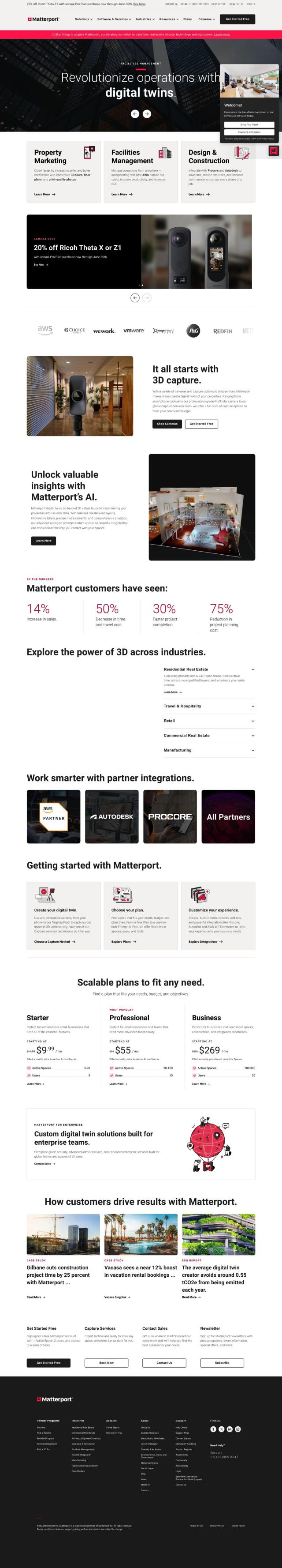
Matterport screenshot thumbnail

Matterport

Another option is Matterport, which offers 3D digital twins of real-world sites. Its immersive virtual experiences can be used to promote properties, manage facilities and oversee construction projects. Matterport offers a range of camera capture choices, virtual tours and AI-based analytics, and it can be integrated with industry tools like Procore and Autodesk.
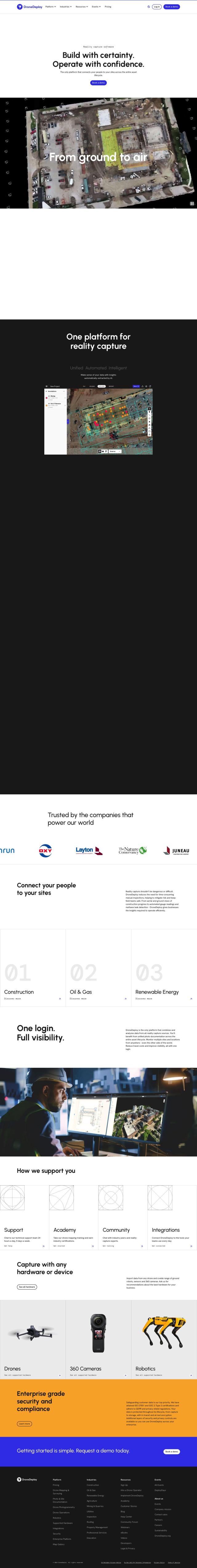
DroneDeploy screenshot thumbnail

DroneDeploy

If you want a more complete package, check out DroneDeploy. The service combines drone mapping and photo documentation to capture and analyze data across an asset's lifetime. It offers AI-based data extraction and is used in construction, oil and gas and renewable energy, where customers can track progress and quickly identify problems.

Polycam screenshot thumbnail

Polycam

Last, Polycam offers a range of 3D capture and creation tools, including LiDAR scanning and 360-degree panorama capture. It's available on multiple platforms, and Polycam has a library of free 3D models and can be used to view and share augmented reality scenes, too.

Additional AI Projects

Hexagon screenshot thumbnail

Hexagon

Combines sensor, software, and autonomous technologies to increase efficiency, reduce waste, and improve sustainability across industries through data-driven digital reality solutions.

RealityCapture screenshot thumbnail

RealityCapture

Automatically generates photorealistic 3D assets and environments from photos and/or laser scans, creating textured 3D meshes and orthographic projections.

Esri screenshot thumbnail

Esri

Uncover hidden patterns and drive predictive modeling with spatial analytics and machine learning, combining location-based data for innovative insights.

echo3D screenshot thumbnail

echo3D

Streamline 3D content management with real-time updates, compression, and version control, and deploy instantly across platforms and devices.

MapmyIndia screenshot thumbnail

MapmyIndia

Seamlessly navigate and optimize last-mile operations with integrated navigation, route planning, and location intelligence solutions powered by India's best maps.

AI Clearing screenshot thumbnail

AI Clearing

Generates 3D site reports with 100% site coverage, providing accurate and efficient progress monitoring, reducing re-work costs and litigation risks.

Blockade Labs screenshot thumbnail

Blockade Labs

Generate 360° panoramic worlds with AI-powered text prompts or sketches, refining scenes with art styles, remixing, and 3D mesh exports for immersive experiences.

Immersity AI screenshot thumbnail

Immersity AI

Convert 2D imagery and video into immersive 3D experiences with detailed depth maps, expanding creative possibilities for commercial use.

3DFY.ai screenshot thumbnail

3DFY.ai

Generate high-quality 3D models from text prompts or single images, rapidly creating engaging 3D assets at scale with unprecedented efficiency.

CARTO screenshot thumbnail

CARTO

Analyze and visualize spatial data at any scale with native cloud integration, intuitive drag-and-drop interface, and built-in GenAI capabilities.

Depthify.ai screenshot thumbnail

Depthify.ai

Convert 2D photos and videos into 3D spatial content with AI-powered depth, stereo, and spatial encoding for immersive experiences on Apple Vision Pro and Meta Quest.

Mapbox screenshot thumbnail

Mapbox

Create customizable, interactive maps with live-updating data and advanced navigation features for web, mobile, automotive, and AR applications.

ArcSoft screenshot thumbnail

ArcSoft

Enhances image quality and user experience with cutting-edge computer vision technologies for various devices and applications.

Interior AI screenshot thumbnail

Interior AI

Upload a photo and instantly redesign interiors with photorealistic renderings, choosing from 50+ styles and modes, including virtual staging for real estate listings.

Avataar screenshot thumbnail

Avataar

Create immersive 3D stories and videos with a fluid blend of digital and real-world elements, leveraging AI for easy model generation and cost savings.

Visoid screenshot thumbnail

Visoid

Creates high-quality 3D images in minutes, allowing architects to experiment with different materials, lighting, and seasons in a single, intuitive tool.

Lumiere3D screenshot thumbnail

Lumiere3D

Creates stunning 3D product videos with AI-driven camera motion, effects, and photorealistic models, all in a matter of minutes.

mnml.ai screenshot thumbnail

mnml.ai

Convert sketches and 3D models into high-quality renderings and variations with a range of AI tools for architectural and interior design projects.

Coohom screenshot thumbnail

Coohom

Create 3D visualizations and render photorealistic designs in minutes, leveraging AI templates and a vast 3D furniture model library to streamline the design process.

Move AI screenshot thumbnail

Move AI

Capture realistic human motion with AI-powered 2D-to-3D video conversion, allowing for flexible and high-quality motion data in any environment.